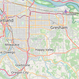
Camas Map, Satellite view of Camas, Washington
Camas is a city located in Clark County, Washington, USA.
Location informations of Camas
Latitude of city of Camas is 45.58706 and longitude of city of Camas is -122.39954- What Country is Camas In? Camas is located in the United States of America.
- What State is Camas located in? Camas is located in Washington.
- What County is Camas In? The County of Camas is Clark County
Camas, Washington (WA), USA Geographic Information
| Country | United States |
| Country Code | US |
| State Name | Washington |
| Latitude | 45.58706 |
| Longitude | -122.39954 |
| DMS Lat | 45°35'13.416" N |
| DMS Long | 122°23'58.344" W |
| DMS coordinates : | 45°35'13.416" N 122°23'58.344" W |
Current Date and Time in Camas, Washington, USA
| Camas Time Zone : America/Los_Angeles |
What day is it in Camas right now?Tuesday (May 20, 2025) |
What time is it?Current local time and date at Camas is 11:28:30 (05/20/2025) : (America/Los_Angeles) |
Postcode / zip code of Camas
Camas is the actual or alternate city name associated with 2 ZIP Codes by the US Postal Service.
List of all postal codes in Camas, Washington, United States.
98607 Zip Code 98682 Zip Code
Online Map of Camas - road map, satellite view and street view


Check out our interactive map of Camas, Washington and you'll easily find your way around the Camas major roads and highways.
Satellite Map of Camas, WA, USA
This is online map of the address Camas, WA, United States. You may use button to move and zoom in / out. The map information is for reference only.
Portland Troutdale Airport (4.19 Km / 2.60 Miles)
Grove Field (4.54 Km / 2.82 Miles)
Orbit Heliport (6.62 Km / 4.11 Miles)
Mount Hood Medical Center Heliport (7.93 Km / 4.92 Miles)
Birdsdale Airport (8.31 Km / 5.16 Miles)
Green Mountain STOLport (10.20 Km / 6.34 Miles)
Division Street Airport (10.32 Km / 6.41 Miles)
Skylife Airport (10.64 Km / 6.61 Miles)
Evergreen Field (10.79 Km / 6.70 Miles)
Wallace Heliport (11.02 Km / 6.85 Miles)
Evergreen North-South Airpark (11.33 Km / 7.04 Miles)
Pleasant Farm Airport (11.50 Km / 7.14 Miles)
Trohs Skypark (11.60 Km / 7.20 Miles)
Rok Airport (11.90 Km / 7.40 Miles)
Woodland Park Hospital Heliport (13.23 Km / 8.22 Miles)
St Joseph Community Hospital Heliport (14.35 Km / 8.92 Miles)
Southwest Washington Medical Center Heliport (14.60 Km / 9.07 Miles)
Fly For Fun Airport (14.66 Km / 9.11 Miles)
Portland Adventist Medical Center Heliport (14.77 Km / 9.18 Miles)
Portland International Airport (15.44 Km / 9.60 Miles)
Liberty Middle School (590 m / 0.37 Miles)
Helen Baller Elem (743 m / 0.46 Miles)
Hayes Freedom High School (789 m / 0.49 Miles)
Homelink River (1.09 Km / 0.67 Miles)
Woodburn Elementary (2.09 Km / 1.30 Miles)
Dorothy Fox (2.72 Km / 1.69 Miles)
Papermaker Preschool (2.81 Km / 1.75 Miles)
Camas High School (2.81 Km / 1.75 Miles)
Lacamas Lake Elementary (2.90 Km / 1.80 Miles)
Grass Valley Elementary (4.17 Km / 2.59 Miles)
Hathaway Elementary (4.23 Km / 2.63 Miles)
Prune Hill Elem (4.40 Km / 2.74 Miles)
Skyridge Middle School (4.90 Km / 3.04 Miles)
List of places near to Camas
| Name | Distance |
|---|---|
| Washougal | 3.62 Km / 2.25 Miles |
| Troutdale | 5.40 Km / 3.36 Miles |
| Fern Prairie | 5.50 Km / 3.42 Miles |
| Fairview | 6.03 Km / 3.75 Miles |
| Wood Village | 6.05 Km / 3.76 Miles |
| Gresham | 10.19 Km / 6.33 Miles |
| Maywood Park | 13.08 Km / 8.13 Miles |
| Orchards | 15.35 Km / 9.54 Miles |
| Five Corners | 17.43 Km / 10.83 Miles |
| Hockinson | 18.10 Km / 11.25 Miles |
| Happy Valley | 18.63 Km / 11.58 Miles |
| Damascus | 19.40 Km / 12.05 Miles |
| Barberton | 19.48 Km / 12.10 Miles |
| Brush Prairie | 19.83 Km / 12.32 Miles |
| Portland | 20.28 Km / 12.60 Miles |
| Venersborg | 20.85 Km / 12.96 Miles |
| Minnehaha | 20.96 Km / 13.02 Miles |
| Vancouver | 21.17 Km / 13.15 Miles |
| Hazel Dell | 22.53 Km / 14.00 Miles |
| Meadow Glade | 22.79 Km / 14.16 Miles |
| Milwaukie | 23.54 Km / 14.63 Miles |
| Sandy | 23.68 Km / 14.71 Miles |
| Salmon Creek | 23.77 Km / 14.77 Miles |
| Battle Ground | 23.94 Km / 14.88 Miles |
| Mount Vista | 24.43 Km / 15.18 Miles |
| Johnson City | 24.65 Km / 15.32 Miles |