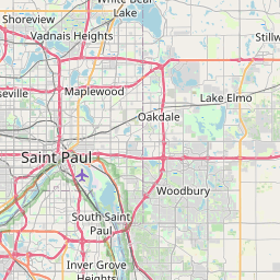
Landfall Map, Satellite view of Landfall, Minnesota
Landfall is a city located in Washington County, Minnesota, USA.
Location informations of Landfall
Latitude of city of Landfall is 44.95080 and longitude of city of Landfall is -92.97660- What Country is Landfall In? Landfall is located in the United States of America.
- What State is Landfall located in? Landfall is located in Minnesota.
- What County is Landfall In? The County of Landfall is Washington County
Landfall, Minnesota (MN), USA Geographic Information
| Country | United States |
| Country Code | US |
| State Name | Minnesota |
| Latitude | 44.9508 |
| Longitude | -92.9766 |
| DMS Lat | 44°57'2.88" N |
| DMS Long | 92°58'35.76" W |
| DMS coordinates : | 44°57'2.88" N 92°58'35.76" W |
Current Date and Time in Landfall, Minnesota, USA
| Landfall Time Zone : America/Chicago |
What day is it in Landfall right now?Saturday (May 24, 2025) |
What time is it?Current local time and date at Landfall is 15:11:36 (05/24/2025) : (America/Chicago) |
Postcode / zip code of Landfall
Landfall is the actual or alternate city name associated with 1 ZIP Codes by the US Postal Service.
List of all postal codes in Landfall, Minnesota, United States.
55128 Zip Code
Online Map of Landfall - road map, satellite view and street view


Check out our interactive map of Landfall, Minnesota and you'll easily find your way around the Landfall major roads and highways.
Satellite Map of Landfall, MN, USA
This is online map of the address Landfall, MN, United States. You may use button to move and zoom in / out. The map information is for reference only.
St Paul Downtown Holman Field (6.81 Km / 4.23 Miles)
Regions Hospital Heliport (9.25 Km / 5.74 Miles)
St. Joseph's Hospital Heliport (9.75 Km / 6.06 Miles)
Children's Hospital St Paul Heliport (10.36 Km / 6.44 Miles)
Lake Elmo Airport (10.84 Km / 6.73 Miles)
South St Paul Municipal Richard E Fleming field (11.32 Km / 7.04 Miles)
Walker Field (12.65 Km / 7.86 Miles)
Kollar's Shoreview Marine Seaplane Base (14.86 Km / 9.23 Miles)
Wipline Seaplane Base (15.23 Km / 9.47 Miles)
Wipline Airport (15.32 Km / 9.52 Miles)
White Bear Lake Seaplane Base (15.76 Km / 9.79 Miles)
Radke Airport (15.86 Km / 9.85 Miles)
Winner's Landing Seaplane Base (17.12 Km / 10.64 Miles)
Benson Airport (18.50 Km / 11.49 Miles)
University of Minnesota Hospitals & Clinics Heliport (20.11 Km / 12.50 Miles)
Hudson Hospital & Clinic Heliport (20.41 Km / 12.68 Miles)
Fairview Riverside Medical Center Heliport (20.61 Km / 12.80 Miles)
Minneapolis-Saint Paul International Airport / Wold-Chamberlain Field (20.77 Km / 12.90 Miles)
St Croix Riviera Airport (21.07 Km / 13.09 Miles)
Abbott Northwestern Hospital Heliport (22.32 Km / 13.87 Miles)
OAKDALE ELEMENTARY (1.08 Km / 0.67 Miles)
TARTAN SENIOR HIGH (1.14 Km / 0.71 Miles)
NE Metro Tartan (1.22 Km / 0.76 Miles)
CARVER ELEMENTARY (1.39 Km / 0.86 Miles)
WOODBURY LEADERSHIP ACADEMY (1.51 Km / 0.94 Miles)
ANTHONY LOUIS CENTER (2.08 Km / 1.29 Miles)
WOODBURY ELEMENTARY (2.29 Km / 1.42 Miles)
WOODBURY MIDDLE SCHOOL (2.49 Km / 1.55 Miles)
BATTLE CREEK MIDDLE (2.82 Km / 1.75 Miles)
EARLY CHILDHOOD SPECIAL EDUCATION (2.86 Km / 1.78 Miles)
Beaver Lake Voluntary Pre-K (2.87 Km / 1.78 Miles)
HARMONY LEARNING CENTER (2.87 Km / 1.78 Miles)
SKYVIEW COMMUNITY ELEMENTARY (3.00 Km / 1.87 Miles)
SKYVIEW COMMUNITY MIDDLE (3.00 Km / 1.87 Miles)
EARLY ED BATTLE CREEK (3.18 Km / 1.97 Miles)
BATTLE CREEK ELEMENTARY SCHOOL (3.18 Km / 1.98 Miles)
EAGLE POINT ELEMENTARY (3.22 Km / 2.00 Miles)
ACHIEVE LANGUAGE ACADEMY (3.31 Km / 2.06 Miles)
Early Ed Eastern Heights (3.35 Km / 2.08 Miles)
EASTERN HEIGHTS ELEMENTARY (3.36 Km / 2.09 Miles)
Minnesota School of Cosmetology-Woodbury Campus (2.91 Km / 1.81 Miles)
List of places near to Landfall
| Name | Distance |
|---|---|
| Maplewood | 1.49 Km / 0.93 Miles |
| Oakdale | 1.64 Km / 1.02 Miles |
| Woodbury | 3.29 Km / 2.04 Miles |
| North St. Paul | 6.96 Km / 4.32 Miles |
| South St. Paul | 7.92 Km / 4.92 Miles |
| Lake Elmo | 9.14 Km / 5.68 Miles |
| St. Paul | 9.21 Km / 5.72 Miles |
| Newport | 9.58 Km / 5.95 Miles |
| Pine Springs | 9.61 Km / 5.97 Miles |
| West St. Paul | 10.57 Km / 6.57 Miles |
| Willernie | 11.60 Km / 7.21 Miles |
| St. Paul Park | 12.13 Km / 7.54 Miles |
| Birchwood Village | 12.14 Km / 7.54 Miles |
| Little Canada | 12.17 Km / 7.56 Miles |
| Lilydale | 12.38 Km / 7.69 Miles |
| Inver Grove Heights | 12.56 Km / 7.80 Miles |
| Gem Lake | 12.65 Km / 7.86 Miles |
| West Lakeland | 13.03 Km / 8.10 Miles |
| White Bear Lake | 13.04 Km / 8.10 Miles |
| Sunfish Lake | 13.09 Km / 8.13 Miles |
| Mahtomedi | 13.37 Km / 8.31 Miles |
| Baytown | 13.59 Km / 8.44 Miles |
| Cottage Grove | 13.93 Km / 8.66 Miles |
| Vadnais Heights | 14.11 Km / 8.77 Miles |
| Mendota Heights | 14.76 Km / 9.17 Miles |
| Roseville | 15.44 Km / 9.59 Miles |
| Dellwood | 15.48 Km / 9.62 Miles |
| Falcon Heights | 15.60 Km / 9.69 Miles |
| Grant | 15.74 Km / 9.78 Miles |
| Afton | 16.11 Km / 10.01 Miles |
| Mendota | 16.39 Km / 10.18 Miles |
| Grey Cloud Island | 16.49 Km / 10.25 Miles |
| Lakeland | 16.60 Km / 10.31 Miles |
| Lakeland Shores | 16.73 Km / 10.40 Miles |
| Lake St. Croix Beach | 16.84 Km / 10.46 Miles |
| Oak Park Heights | 16.99 Km / 10.56 Miles |
| St. Marys Point | 17.08 Km / 10.61 Miles |
| White Bear | 17.16 Km / 10.66 Miles |
| Bayport | 17.27 Km / 10.73 Miles |
| Hudson | 17.49 Km / 10.87 Miles |
| Stillwater | 17.82 Km / 11.07 Miles |
| North Hudson | 17.91 Km / 11.13 Miles |
| Arden Hills | 17.96 Km / 11.16 Miles |
| North Oaks | 18.72 Km / 11.63 Miles |
| Lauderdale | 18.79 Km / 11.68 Miles |
| Houlton | 19.00 Km / 11.81 Miles |
| Shoreview | 19.58 Km / 12.17 Miles |
| Denmark | 20.16 Km / 12.53 Miles |
| St. Anthony | 20.76 Km / 12.90 Miles |
| New Brighton | 21.83 Km / 13.56 Miles |