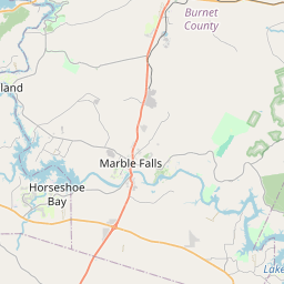
Marble Falls Map, Satellite view of Marble Falls, Texas
Marble Falls is a city located in Burnet County, Texas, USA.
Location informations of Marble Falls
Latitude of city of Marble Falls is 30.57824 and longitude of city of Marble Falls is -98.27280- What Country is Marble Falls In? Marble Falls is located in the United States of America.
- What State is Marble Falls located in? Marble Falls is located in Texas.
- What County is Marble Falls In? The County of Marble Falls is Burnet County
Marble Falls, Texas (TX), USA Geographic Information
| Country | United States |
| Country Code | US |
| State Name | Texas |
| Latitude | 30.57824 |
| Longitude | -98.2728 |
| DMS Lat | 30°34'41.664" N |
| DMS Long | 98°16'22.08" W |
| DMS coordinates : | 30°34'41.664" N 98°16'22.08" W |
Current Date and Time in Marble Falls, Texas, USA
| Marble Falls Time Zone : America/Chicago |
What day is it in Marble Falls right now?Friday (May 30, 2025) |
What time is it?Current local time and date at Marble Falls is 04:49:38 (05/30/2025) : (America/Chicago) |
Postcode / zip code of Marble Falls
Marble Falls is the actual or alternate city name associated with 2 ZIP Codes by the US Postal Service.
List of all postal codes in Marble Falls, Texas, United States.
78654 Zip Code 78657 Zip Code
Online Map of Marble Falls - road map, satellite view and street view


Check out our interactive map of Marble Falls, Texas and you'll easily find your way around the Marble Falls major roads and highways.
Satellite Map of Marble Falls, TX, USA
This is online map of the address Marble Falls, TX, United States. You may use button to move and zoom in / out. The map information is for reference only.
Air Evac Lifeteam Base 49 Heliport (790 m / 0.49 Miles)
McDonald Airstrip (2.39 Km / 1.48 Miles)
Hefner Ranch Airport (4.60 Km / 2.86 Miles)
Slaughter Ranch Airport (4.95 Km / 3.07 Miles)
Baylor Scott & White Marble Falls Medical Center Helipad (7.78 Km / 4.83 Miles)
Goodall SSP Ranch Airport (7.92 Km / 4.92 Miles)
Granite Shoals Bob Sylvester Airpark (9.42 Km / 5.85 Miles)
Horseshoe Bay Resort Airpark (10.00 Km / 6.21 Miles)
Herbert Ranch Airport (10.26 Km / 6.37 Miles)
HBR Heliport (11.63 Km / 7.23 Miles)
Flying X River Ranch Airport (11.65 Km / 7.24 Miles)
Sunrise Beach Airport (13.20 Km / 8.20 Miles)
Spicewood Beach Landing Strip (13.48 Km / 8.38 Miles)
Lakeside Beach Airport (14.80 Km / 9.19 Miles)
Indian Springs Airport (17.36 Km / 10.79 Miles)
Ascension Seton Highland Lakes Hospital Heliport (17.51 Km / 10.88 Miles)
Shirley Williams Airport (18.09 Km / 11.24 Miles)
Burnet Municipal Kate Craddock Field (18.16 Km / 11.28 Miles)
Spicewood Airport (18.58 Km / 11.55 Miles)
Flying X Ranch Airport (19.02 Km / 11.82 Miles)
MARBLE FALLS MIDDLE (847 m / 0.53 Miles)
MARBLE FALLS EL (1.33 Km / 0.82 Miles)
FALLS CAREER H S (1.41 Km / 0.88 Miles)
MARBLE FALLS H S (2.05 Km / 1.28 Miles)
COLT EL (3.66 Km / 2.28 Miles)
List of places near to Marble Falls
| Name | Distance |
|---|---|
| Meadowlakes | 2.86 Km / 1.78 Miles |
| Cottonwood Shores | 5.50 Km / 3.42 Miles |
| Granite Shoals | 10.71 Km / 6.65 Miles |
| Horseshoe Bay | 11.13 Km / 6.92 Miles |
| Highland Haven | 12.24 Km / 7.61 Miles |
| Sunrise Beach Village | 13.35 Km / 8.30 Miles |
| Round Mountain | 17.70 Km / 11.00 Miles |
| Kingsland | 18.35 Km / 11.40 Miles |
| Burnet | 20.46 Km / 12.71 Miles |
| Buchanan Dam | 23.51 Km / 14.61 Miles |