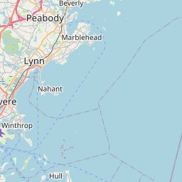
Marblehead Map, Satellite view of Marblehead, Massachusetts
Marblehead is a town located in Essex County, Massachusetts, USA.
Location informations of Marblehead
Latitude of city of Marblehead is 42.49563 and longitude of city of Marblehead is -70.83582- What Country is Marblehead In? Marblehead is located in the United States of America.
- What State is Marblehead located in? Marblehead is located in Massachusetts.
- What County is Marblehead In? The County of Marblehead is Essex County
Marblehead, Massachusetts (MA), USA Geographic Information
| Country | United States |
| Country Code | US |
| State Name | Massachusetts |
| Latitude | 42.49563 |
| Longitude | -70.83582 |
| DMS Lat | 42°29'44.268" N |
| DMS Long | 70°50'8.952" W |
| DMS coordinates : | 42°29'44.268" N 70°50'8.952" W |
Current Date and Time in Marblehead, Massachusetts, USA
| Marblehead Time Zone : America/New_York |
What day is it in Marblehead right now?Friday (June 6, 2025) |
What time is it?Current local time and date at Marblehead is 6/6/2025 - 9:21:17 PM |
Postcode / zip code of Marblehead
Marblehead is the actual or alternate city name associated with 1 ZIP Codes by the US Postal Service.
List of all postal codes in Marblehead, Massachusetts, United States.
01945 Zip Code
Area Codes Marblehead, Massachusetts, USA
Marblehead, Massachusetts covers 2 Area Codes
339 Area Code 781 Area CodeOnline Map of Marblehead - road map, satellite view and street view


Check out our interactive map of Marblehead, Massachusetts and you'll easily find your way around the Marblehead major roads and highways.
Satellite Map of Marblehead, MA, USA
This is online map of the address Marblehead, MA, United States. You may use button to move and zoom in / out. The map information is for reference only.
Coast Guard Air Station Salem Seaplane Base (4.32 Km / 2.68 Miles)
Idlewide Heliport (7.19 Km / 4.47 Miles)
Beverly Hospital Heliport (8.56 Km / 5.32 Miles)
Seagate Heliport (8.83 Km / 5.49 Miles)
Metro-Swift Heliport (9.07 Km / 5.64 Miles)
Gear Plant Heliport (11.68 Km / 7.26 Miles)
Beverly Regional Airport (11.86 Km / 7.37 Miles)
Crowhurst Heliport (11.98 Km / 7.44 Miles)
Long Hill Orchard Heliport (11.99 Km / 7.45 Miles)
Rent-A-Tool Heliport (14.33 Km / 8.91 Miles)
Devon Glen Heliport (14.42 Km / 8.96 Miles)
Ames Heliport (15.30 Km / 9.51 Miles)
Ferncroft Village Heliport (15.79 Km / 9.81 Miles)
Sagamore Hill Heliport (16.28 Km / 10.12 Miles)
Rider Heliport (18.76 Km / 11.66 Miles)
Snow Airport (19.05 Km / 11.84 Miles)
Coast Guard Air Station Ten Pound Island Seaplane Base (19.07 Km / 11.85 Miles)
US Coast Guard Gloucester Heliport (19.22 Km / 11.94 Miles)
Logan International Airport (20.16 Km / 12.53 Miles)
Wheeler's Point Heliport (20.43 Km / 12.70 Miles)
Elbridge Gerry (1.69 Km / 1.05 Miles)
Marblehead Community Charter Public School (2.03 Km / 1.26 Miles)
Marblehead Veterans Middle School (2.11 Km / 1.31 Miles)
L H Coffin (2.40 Km / 1.49 Miles)
Village School (2.63 Km / 1.63 Miles)
Marblehead High (2.71 Km / 1.68 Miles)
Malcolm L Bell (2.93 Km / 1.82 Miles)
Glover (3.64 Km / 2.26 Miles)
Horace Mann Laboratory (4.67 Km / 2.90 Miles)
Saltonstall School (4.98 Km / 3.09 Miles)
Salem State University (4.55 Km / 2.83 Miles)
List of places near to Marblehead
| Name | Distance |
|---|---|
| Marblehead (CDP) | 1.87 Km / 1.16 Miles |
| Swampscott | 5.48 Km / 3.41 Miles |
| Salem | 5.66 Km / 3.52 Miles |
| Swampscott (CDP) | 7.24 Km / 4.50 Miles |
| Beverly | 7.87 Km / 4.89 Miles |
| Peabody | 8.41 Km / 5.23 Miles |
| Manchester-by-the-Sea | 9.67 Km / 6.01 Miles |
| Lynn | 9.86 Km / 6.13 Miles |
| Nahant (CDP) | 10.28 Km / 6.39 Miles |
| Nahant | 11.56 Km / 7.18 Miles |
| Danvers (CDP) | 11.73 Km / 7.29 Miles |
| Wenham | 12.31 Km / 7.65 Miles |
| Danvers | 12.83 Km / 7.97 Miles |
| Hamilton | 14.63 Km / 9.09 Miles |
| Saugus (CDP) | 14.69 Km / 9.13 Miles |
| Saugus | 14.92 Km / 9.27 Miles |
| Essex (CDP) | 15.78 Km / 9.81 Miles |
| Essex | 16.95 Km / 10.53 Miles |
| Lynnfield | 17.14 Km / 10.65 Miles |
| Winthrop Town | 17.34 Km / 10.77 Miles |
| Revere | 17.40 Km / 10.81 Miles |
| Hull | 17.71 Km / 11.00 Miles |
| Lynnfield (CDP) | 18.05 Km / 11.22 Miles |
| Topsfield (CDP) | 18.33 Km / 11.39 Miles |
| Topsfield | 18.45 Km / 11.46 Miles |
| Wakefield | 18.74 Km / 11.64 Miles |
| Middleton | 18.98 Km / 11.79 Miles |
| Melrose | 19.34 Km / 12.02 Miles |
| Wakefield (CDP) | 19.47 Km / 12.10 Miles |
| Gloucester | 19.54 Km / 12.14 Miles |
| Chelsea | 19.87 Km / 12.35 Miles |
| Everett | 20.33 Km / 12.63 Miles |
| Ipswich (CDP) | 20.42 Km / 12.69 Miles |
| Malden | 20.46 Km / 12.71 Miles |
| Reading (CDP) | 21.53 Km / 13.38 Miles |
| Stoneham | 21.60 Km / 13.42 Miles |
| Stoneham (CDP) | 21.69 Km / 13.48 Miles |
| Ipswich | 22.28 Km / 13.84 Miles |
| Hull (CDP) | 22.32 Km / 13.87 Miles |
| North Reading | 22.35 Km / 13.89 Miles |
| Reading | 22.53 Km / 14.00 Miles |
| Boxford (CDP) | 22.64 Km / 14.07 Miles |
| Medford | 23.78 Km / 14.78 Miles |
| Boston | 23.89 Km / 14.84 Miles |
| Somerville | 24.75 Km / 15.38 Miles |
| Rowley (CDP) | 24.84 Km / 15.43 Miles |