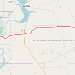
Spavinaw Map, Satellite view of Spavinaw, Oklahoma
Spavinaw is a town located in Mayes County, Oklahoma, USA.
Location informations of Spavinaw
Latitude of city of Spavinaw is 36.39120 and longitude of city of Spavinaw is -95.04663- What Country is Spavinaw In? Spavinaw is located in the United States of America.
- What State is Spavinaw located in? Spavinaw is located in Oklahoma.
- What County is Spavinaw In? The County of Spavinaw is Mayes County
Spavinaw, Oklahoma (OK), USA Geographic Information
| Country | United States |
| Country Code | US |
| State Name | Oklahoma |
| Latitude | 36.3912 |
| Longitude | -95.04663 |
| DMS Lat | 36°23'28.32" N |
| DMS Long | 95°2'47.868" W |
| DMS coordinates : | 36°23'28.32" N 95°2'47.868" W |
Current Date and Time in Spavinaw, Oklahoma, USA
| Spavinaw Time Zone : America/Chicago |
What day is it in Spavinaw right now?Tuesday (May 20, 2025) |
What time is it?Current local time and date at Spavinaw is 18:16:13 (05/20/2025) : (America/Chicago) |
Postcode / zip code of Spavinaw
Spavinaw is the actual or alternate city name associated with 1 ZIP Codes by the US Postal Service.
List of all postal codes in Spavinaw, Oklahoma, United States.
74366 Zip Code
Online Map of Spavinaw - road map, satellite view and street view


Check out our interactive map of Spavinaw, Oklahoma and you'll easily find your way around the Spavinaw major roads and highways.
Satellite Map of Spavinaw, OK, USA
This is online map of the address Spavinaw, OK, United States. You may use button to move and zoom in / out. The map information is for reference only.
Red Stevenson Property Heliport (11.06 Km / 6.87 Miles)
Grandcraft Landing Strip (11.19 Km / 6.95 Miles)
Grand Isle Airport (11.70 Km / 7.27 Miles)
Siegfried Point Heliport (11.71 Km / 7.28 Miles)
Lewis North Airport (12.70 Km / 7.89 Miles)
Disney Airport (13.44 Km / 8.35 Miles)
Stearmans Roost Airport (13.88 Km / 8.62 Miles)
Bacon's Heliport (14.12 Km / 8.77 Miles)
Lakemont Shores Heliport (15.56 Km / 9.67 Miles)
South Grand Lake Regional Airport (16.89 Km / 10.49 Miles)
Harbor's in Heliport (19.91 Km / 12.37 Miles)
Jay Heliport (22.55 Km / 14.01 Miles)
Longs Airport North Airport (23.96 Km / 14.89 Miles)
Cherokee Seaplane Base (24.32 Km / 15.11 Miles)
Sam Hider Community Health Center Heliport (24.47 Km / 15.20 Miles)
Hillcrest Hospital Pryor Heliport (24.81 Km / 15.41 Miles)
List of places near to Spavinaw
| Name | Distance |
|---|---|
| Hoot Owl | 7.55 Km / 4.69 Miles |
| Strang | 7.84 Km / 4.87 Miles |
| Langley | 8.29 Km / 5.15 Miles |
| Pensacola | 10.33 Km / 6.42 Miles |
| Disney | 10.40 Km / 6.46 Miles |
| Old Eucha | 10.44 Km / 6.49 Miles |
| Kenwood | 10.91 Km / 6.78 Miles |
| Wickliffe | 11.92 Km / 7.41 Miles |
| Tagg Flats | 12.29 Km / 7.64 Miles |
| Grand Lake Towne | 12.76 Km / 7.93 Miles |
| Salina | 14.52 Km / 9.02 Miles |
| Ketchum | 14.79 Km / 9.19 Miles |
| Bull Hollow | 15.17 Km / 9.43 Miles |
| Pump Back | 15.97 Km / 9.92 Miles |
| Drowning Creek | 16.69 Km / 10.37 Miles |
| New Eucha | 17.40 Km / 10.81 Miles |
| Rose | 19.15 Km / 11.90 Miles |
| Adair | 20.74 Km / 12.89 Miles |
| Zena | 20.85 Km / 12.96 Miles |
| Cleora | 21.94 Km / 13.63 Miles |
| Dennis | 21.96 Km / 13.65 Miles |
| Big Cabin | 22.59 Km / 14.04 Miles |
| Jay | 22.60 Km / 14.04 Miles |
| Brush Creek | 23.49 Km / 14.60 Miles |
| Leach | 23.52 Km / 14.61 Miles |
| Locust Grove | 23.86 Km / 14.83 Miles |
| Snake Creek | 24.35 Km / 15.13 Miles |
| Sportsmen Acres | 24.48 Km / 15.21 Miles |