Rolling Hills Map, Satellite view of Rolling Hills, California
Rolling Hills is a city located in Los Angeles County, California, USA.
Location informations of Rolling Hills
Latitude of city of Rolling Hills is 33.75696 and longitude of city of Rolling Hills is -118.35396- What Country is Rolling Hills In? Rolling Hills is located in the United States of America.
- What State is Rolling Hills located in? Rolling Hills is located in California.
- What County is Rolling Hills In? The County of Rolling Hills is Los Angeles County
Rolling Hills, California (CA), USA Geographic Information
| Country | United States |
| Country Code | US |
| State Name | California |
| Latitude | 33.75696 |
| Longitude | -118.35396 |
| DMS Lat | 33°45'25.056" N |
| DMS Long | 118°21'14.256" W |
| DMS coordinates : | 33°45'25.056" N 118°21'14.256" W |
Current Date and Time in Rolling Hills, California, USA
| Rolling Hills Time Zone : America/Los_Angeles |
What day is it in Rolling Hills right now?Tuesday (June 10, 2025) |
What time is it?Current local time and date at Rolling Hills is 6/10/2025 - 3:42:53 PM |
Postcode / zip code of Rolling Hills
Rolling Hills is the actual or alternate city name associated with 1 ZIP Codes by the US Postal Service.
List of all postal codes in Rolling Hills, California, United States.
90274 Zip Code
Area Codes Rolling Hills, California, USA
Rolling Hills, California covers 1 Area Codes
424 Area CodeOnline Map of Rolling Hills - road map, satellite view and street view
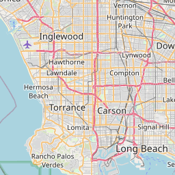
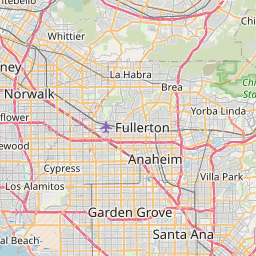
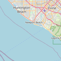


Check out our interactive map of Rolling Hills, California and you'll easily find your way around the Rolling Hills major roads and highways.
Satellite Map of Rolling Hills, CA, USA
This is online map of the address Rolling Hills, CA, United States. You may use button to move and zoom in / out. The map information is for reference only.
Northrop Palos Verdes Heliport (3.17 Km / 1.97 Miles)
Long Point Heliport (4.60 Km / 2.86 Miles)
Zamperini Field (5.32 Km / 3.31 Miles)
Point Vicente Lighthouse Helipad (5.49 Km / 3.41 Miles)
Defense Fuel Support Point San Pedro Helipad (5.68 Km / 3.53 Miles)
Wilmington / Los Angeles Harbor Airport (7.16 Km / 4.45 Miles)
Catalina Air-Sea Terminal Heliport (7.35 Km / 4.57 Miles)
Ports O'Call Heliport (7.72 Km / 4.80 Miles)
Reeves Field (9.00 Km / 5.59 Miles)
NAS Terminal Island Seaplane Base (9.40 Km / 5.84 Miles)
Cosmodyne Heliport (9.72 Km / 6.04 Miles)
Harbor/UCLA Medical Center Heliport (9.83 Km / 6.11 Miles)
Redondo Generating Station Helipad (11.11 Km / 6.90 Miles)
Toyota Helistop (11.71 Km / 7.28 Miles)
Holiday Inn Torrance Helipad (12.03 Km / 7.48 Miles)
Carson Sheriff Station Heliport (12.08 Km / 7.51 Miles)
Torrance Field / Bay Cities Airport (13.00 Km / 8.08 Miles)
Goodyear Blimp Base Airport (13.09 Km / 8.13 Miles)
Residence Inn by Marriott Long Beach Downtown Helipad (14.10 Km / 8.76 Miles)
Hilton Long Beach Helipad (14.17 Km / 8.81 Miles)
Rancho del Mar High (Continuation) (501 m / 0.31 Miles)
Miraleste Intermediate (2.23 Km / 1.39 Miles)
Soleado Elementary (2.30 Km / 1.43 Miles)
Dapplegray Elementary (2.49 Km / 1.55 Miles)
Ridgecrest Intermediate (2.51 Km / 1.56 Miles)
Mira Catalina Elementary (2.56 Km / 1.59 Miles)
Palos Verdes Peninsula High (2.97 Km / 1.85 Miles)
Rancho Vista Elementary (3.36 Km / 2.09 Miles)
Rudecinda Sepulveda Dodson Middle (3.65 Km / 2.27 Miles)
Crestwood Street Elementary (3.93 Km / 2.44 Miles)
Silver Spur Elementary (4.03 Km / 2.50 Miles)
Cornerstone at Pedregal Elementary (4.32 Km / 2.68 Miles)
Seventh Street Elementary (4.43 Km / 2.75 Miles)
Ernest P. Willenberg Special Education Center (4.51 Km / 2.80 Miles)
Park Western Place Elementary (4.63 Km / 2.88 Miles)
Vista Grande Elementary (4.74 Km / 2.94 Miles)
South Shores/CSUDH Visual and Performing Arts (4.80 Km / 2.98 Miles)
Walteria Elementary (4.87 Km / 3.03 Miles)
Marymount California University (3.11 Km / 1.93 Miles)
List of places near to Rolling Hills
| Name | Distance |
|---|---|
| Rancho Palos Verdes | 3.36 Km / 2.09 Miles |
| Rolling Hills Estates | 3.45 Km / 2.14 Miles |
| Lomita | 5.32 Km / 3.31 Miles |
| Palos Verdes Estates | 5.89 Km / 3.66 Miles |
| Torrance | 8.86 Km / 5.51 Miles |
| West Carson | 9.16 Km / 5.69 Miles |
| Carson | 10.62 Km / 6.60 Miles |
| Redondo Beach | 10.73 Km / 6.67 Miles |
| Hermosa Beach | 12.44 Km / 7.73 Miles |
| Lawndale | 14.49 Km / 9.00 Miles |
| Alondra Park | 14.89 Km / 9.25 Miles |
| Manhattan Beach | 15.15 Km / 9.41 Miles |
| Gardena | 15.19 Km / 9.44 Miles |
| Long Beach | 15.27 Km / 9.49 Miles |
| West Rancho Dominguez | 17.06 Km / 10.60 Miles |
| Hawthorne | 17.73 Km / 11.02 Miles |
| Del Aire | 17.76 Km / 11.04 Miles |
| Signal Hill | 17.99 Km / 11.18 Miles |
| El Segundo | 18.94 Km / 11.77 Miles |
| West Athens | 19.08 Km / 11.86 Miles |
| Compton | 19.79 Km / 12.30 Miles |
| Lennox | 20.14 Km / 12.51 Miles |
| Willowbrook | 21.05 Km / 13.08 Miles |
| Westmont | 21.06 Km / 13.09 Miles |
| East Rancho Dominguez | 21.47 Km / 13.34 Miles |
| Inglewood | 22.76 Km / 14.14 Miles |
| Lakewood | 22.99 Km / 14.29 Miles |
| Seal Beach | 23.10 Km / 14.35 Miles |
| Paramount | 23.21 Km / 14.42 Miles |
| Lynwood | 23.34 Km / 14.50 Miles |