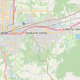
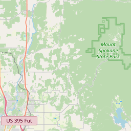
Spokane Valley Map, Satellite view of Spokane Valley, Washington
Spokane Valley is a city located in Spokane County, Washington, USA.
Location informations of Spokane Valley
Latitude of city of Spokane Valley is 47.67323 and longitude of city of Spokane Valley is -117.23937- What Country is Spokane Valley In? Spokane Valley is located in the United States of America.
- What State is Spokane Valley located in? Spokane Valley is located in Washington.
- What County is Spokane Valley In? The County of Spokane Valley is Spokane County
Spokane Valley, Washington (WA), USA Geographic Information
| Country | United States |
| Country Code | US |
| State Name | Washington |
| Latitude | 47.67323 |
| Longitude | -117.23937 |
| DMS Lat | 47°40'23.628" N |
| DMS Long | 117°14'21.732" W |
| DMS coordinates : | 47°40'23.628" N 117°14'21.732" W |
Current Date and Time in Spokane Valley, Washington, USA
| Spokane Valley Time Zone : America/Los_Angeles |
What day is it in Spokane Valley right now?Wednesday (June 18, 2025) |
What time is it?Current local time and date at Spokane Valley is 6/18/2025 - 5:12:12 PM |
Postcode / zip code of Spokane Valley
Spokane Valley is the actual or alternate city name associated with 8 ZIP Codes by the US Postal Service.
List of all postal codes in Spokane Valley, Washington, United States.
99016 Zip Code 99027 Zip Code 99037 Zip Code 99206 Zip Code 99211 Zip Code 99212 Zip Code 99215 Zip Code 99216 Zip Code
Area Codes Spokane Valley, Washington, USA
Spokane Valley, Washington covers 1 Area Codes
509 Area CodeOnline Map of Spokane Valley - road map, satellite view and street view


Check out our interactive map of Spokane Valley, Washington and you'll easily find your way around the Spokane Valley major roads and highways.
Satellite Map of Spokane Valley, WA, USA
This is online map of the address Spokane Valley, WA, United States. You may use button to move and zoom in / out. The map information is for reference only.
N A Degerstrom Yard Heliport (3.42 Km / 2.13 Miles)
Felts Field (6.35 Km / 3.95 Miles)
Tai's Landing Airport (6.53 Km / 4.06 Miles)
Birdhouse Heliport (8.00 Km / 4.97 Miles)
Sky Meadows Airpark (8.42 Km / 5.23 Miles)
Pathfinder Helicopter Heliport (11.71 Km / 7.27 Miles)
Holy Family Hospital Heliport (13.21 Km / 8.21 Miles)
Sacred Heart Medical Center Helistop (13.37 Km / 8.31 Miles)
Multicare Deaconess Hospital Heliport (14.07 Km / 8.74 Miles)
Ellerport Airport (14.34 Km / 8.91 Miles)
Scanlon Airport (15.14 Km / 9.41 Miles)
Mead Flying Service Airport (15.47 Km / 9.61 Miles)
Nichols Ranch Airport (16.06 Km / 9.98 Miles)
Shamrock Port Heliport (16.37 Km / 10.17 Miles)
Sunshine Acres Airport (17.96 Km / 11.16 Miles)
Ox Meadows Airport (17.96 Km / 11.16 Miles)
Boyle R & D Airport (17.99 Km / 11.18 Miles)
Mullan Hill Airport (18.53 Km / 11.51 Miles)
Smith Ranch Airport (18.57 Km / 11.54 Miles)
Hubof's Heliport (19.11 Km / 11.87 Miles)
North Pines Middle School (1.09 Km / 0.68 Miles)
EV Parent Partnership (1.27 Km / 0.79 Miles)
Summit School (1.40 Km / 0.87 Miles)
Spokane Valley Learning Academy (1.40 Km / 0.87 Miles)
Trent School (1.53 Km / 0.95 Miles)
Broadway Elementary (1.71 Km / 1.06 Miles)
Dishman Hills High School (2.06 Km / 1.28 Miles)
Spokane Valley Tech (2.50 Km / 1.55 Miles)
Ness Elementary (2.84 Km / 1.76 Miles)
Opportunity Elementary (3.02 Km / 1.88 Miles)
Progress Elementary School (3.03 Km / 1.88 Miles)
I-TRACC (3.30 Km / 2.05 Miles)
Mica Peak High School (3.30 Km / 2.05 Miles)
Central Valley Early Learning Center (3.30 Km / 2.05 Miles)
School to Life (3.30 Km / 2.05 Miles)
Spokane Valley Transition School (3.37 Km / 2.09 Miles)
Spokane Valley High School (3.39 Km / 2.11 Miles)
McDonald Elementary School (3.44 Km / 2.14 Miles)
re-engagement (3.46 Km / 2.15 Miles)
Adams Elementary (3.57 Km / 2.22 Miles)
Carrington College-Spokane (2.17 Km / 1.35 Miles)
Studio Beauty School (2.89 Km / 1.79 Miles)
Paul Mitchell the School-Spokane (3.45 Km / 2.14 Miles)
List of places near to Spokane Valley
| Name | Distance |
|---|---|
| Millwood | 3.37 Km / 2.09 Miles |
| Liberty Lake | 11.35 Km / 7.05 Miles |
| Otis Orchards-East Farms | 12.07 Km / 7.50 Miles |
| Mead | 13.58 Km / 8.44 Miles |
| Spokane | 14.07 Km / 8.74 Miles |
| Town and Country | 14.91 Km / 9.26 Miles |
| Country Homes | 14.92 Km / 9.27 Miles |
| State Line | 15.59 Km / 9.69 Miles |
| Fairwood | 16.91 Km / 10.51 Miles |
| Green Bluff | 17.31 Km / 10.76 Miles |
| Hauser | 19.31 Km / 12.00 Miles |
| Post Falls | 22.10 Km / 13.73 Miles |