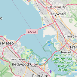
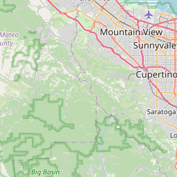
Stanford Map, Satellite view of Stanford, California
Stanford is a census-designated place (CDP) located in Santa Clara County, California, USA.
Location informations of Stanford
Latitude of city of Stanford is 37.42411 and longitude of city of Stanford is -122.16608- What Country is Stanford In? Stanford is located in the United States of America.
- What State is Stanford located in? Stanford is located in California.
- What County is Stanford In? The County of Stanford is Santa Clara County
Stanford, California (CA), USA Geographic Information
| Country | United States |
| Country Code | US |
| State Name | California |
| Latitude | 37.42411 |
| Longitude | -122.16608 |
| DMS Lat | 37°25'26.796" N |
| DMS Long | 122°9'57.888" W |
| DMS coordinates : | 37°25'26.796" N 122°9'57.888" W |
Current Date and Time in Stanford, California, USA
| Stanford Time Zone : America/Los_Angeles |
What day is it in Stanford right now?Tuesday (May 20, 2025) |
What time is it?Current local time and date at Stanford is 15:40:26 (05/20/2025) : (America/Los_Angeles) |
Postcode / zip code of Stanford
Stanford is the actual or alternate city name associated with 2 ZIP Codes by the US Postal Service.
List of all postal codes in Stanford, California, United States.
94305 Zip Code 94309 Zip Code
Online Map of Stanford - road map, satellite view and street view


Check out our interactive map of Stanford, California and you'll easily find your way around the Stanford major roads and highways.
Satellite Map of Stanford, CA, USA
This is online map of the address Stanford, CA, United States. You may use button to move and zoom in / out. The map information is for reference only.
Goddard Airport (948 m / 0.59 Miles)
Stanford Health Care East Heliport (1.44 Km / 0.90 Miles)
Stanford Health Care West Heliport (1.54 Km / 0.96 Miles)
Mountain View Airport (5.92 Km / 3.68 Miles)
Palo Alto Airport of Santa Clara County (6.10 Km / 3.79 Miles)
Hiller Airfield (6.26 Km / 3.89 Miles)
Ravenswood Substation Helipad (8.09 Km / 5.03 Miles)
Moffett Federal Airfield (10.38 Km / 6.45 Miles)
San Carlos Airport (12.25 Km / 7.61 Miles)
Cooley Field (13.63 Km / 8.47 Miles)
International Science Center Heliport (14.94 Km / 9.29 Miles)
Belmont Airport (15.33 Km / 9.52 Miles)
Santa Clara Valley Airport (15.76 Km / 9.79 Miles)
McCandless Towers Heliport (17.64 Km / 10.96 Miles)
Kaiser Permanente Medical Center Santa Clara Heliport (17.73 Km / 11.02 Miles)
Bay Meadows Airport (18.00 Km / 11.18 Miles)
San Mateo Highlands Airfield (18.16 Km / 11.28 Miles)
San Mateo Airport (18.95 Km / 11.77 Miles)
Centerville Airport (19.54 Km / 12.14 Miles)
Skyways Airport (19.71 Km / 12.25 Miles)
Escondido Elementary (984 m / 0.61 Miles)
Lucille M. Nixon Elementary (1.43 Km / 0.89 Miles)
Palo Alto High (1.68 Km / 1.04 Miles)
Oak Knoll Elementary (2.42 Km / 1.50 Miles)
Addison Elementary (2.77 Km / 1.72 Miles)
Barron Park Elementary (2.82 Km / 1.75 Miles)
Walter Hays Elementary (2.91 Km / 1.81 Miles)
Hillview Middle (3.12 Km / 1.94 Miles)
La Entrada Middle (3.17 Km / 1.97 Miles)
El Carmelo Elementary (3.21 Km / 1.99 Miles)
Frank S. Greene Jr. Middle (3.21 Km / 1.99 Miles)
Juana Briones Elementary (3.82 Km / 2.37 Miles)
Henry M. Gunn High (3.86 Km / 2.40 Miles)
Duveneck Elementary (4.01 Km / 2.49 Miles)
Ohlone Elementary (4.11 Km / 2.55 Miles)
Menlo-Atherton High (4.22 Km / 2.62 Miles)
Jane Lathrop Stanford Middle (4.27 Km / 2.65 Miles)
Ellen Fletcher Middle (4.27 Km / 2.65 Miles)
Fairmeadow Elementary (4.29 Km / 2.67 Miles)
Willow Oaks Elementary (4.34 Km / 2.69 Miles)
Stanford University (602 m / 0.37 Miles)
Menlo College (3.93 Km / 2.44 Miles)
List of places near to Stanford
| Name | Distance |
|---|---|
| Palo Alto | 2.84 Km / 1.76 Miles |
| West Menlo Park | 3.43 Km / 2.13 Miles |
| Menlo Park | 3.60 Km / 2.24 Miles |
| Ladera | 3.91 Km / 2.43 Miles |
| Atherton | 4.99 Km / 3.10 Miles |
| East Palo Alto | 5.44 Km / 3.38 Miles |
| Los Altos Hills | 5.55 Km / 3.45 Miles |
| North Fair Oaks | 6.21 Km / 3.86 Miles |
| Los Altos | 6.31 Km / 3.92 Miles |
| Portola Valley | 7.56 Km / 4.70 Miles |
| Woodside | 7.78 Km / 4.83 Miles |
| Mountain View | 8.41 Km / 5.23 Miles |
| Redwood City | 9.20 Km / 5.72 Miles |
| Loyola | 9.95 Km / 6.18 Miles |
| Emerald Lake Hills | 10.07 Km / 6.26 Miles |
| San Carlos | 12.44 Km / 7.73 Miles |
| Sunnyvale | 13.00 Km / 8.08 Miles |
| Belmont | 14.42 Km / 8.96 Miles |
| La Honda | 15.08 Km / 9.37 Miles |
| Newark | 16.16 Km / 10.04 Miles |
| Cupertino | 16.32 Km / 10.14 Miles |
| Foster City | 17.59 Km / 10.93 Miles |
| Highlands-Baywood Park | 19.20 Km / 11.93 Miles |
| Santa Clara | 20.19 Km / 12.55 Miles |
| Fremont | 20.88 Km / 12.97 Miles |
| San Mateo | 20.89 Km / 12.98 Miles |
| Loma Mar | 21.17 Km / 13.15 Miles |
| Saratoga | 21.85 Km / 13.58 Miles |
| Milpitas | 22.92 Km / 14.24 Miles |
| Union City | 23.08 Km / 14.34 Miles |
| Burbank | 23.56 Km / 14.64 Miles |
| Half Moon Bay | 23.59 Km / 14.66 Miles |
| Fruitdale | 24.16 Km / 15.01 Miles |
| Campbell | 24.43 Km / 15.18 Miles |